KEG SPRINGS, Idaho (KIFI)– Search and rescue crews from both Clark County and Fremont County responded this afternoon after reports of an avalanche near Island Park.
The avalanche was reported in the area of Keg Springs Road. Clark County Dispatch says the call came in at 2:15 p.m.
At this time, Clark County Dispatch does not know how many people were caught in the slide. Authorities are still working to gather information.
We will continue to provide updates as more details become available.
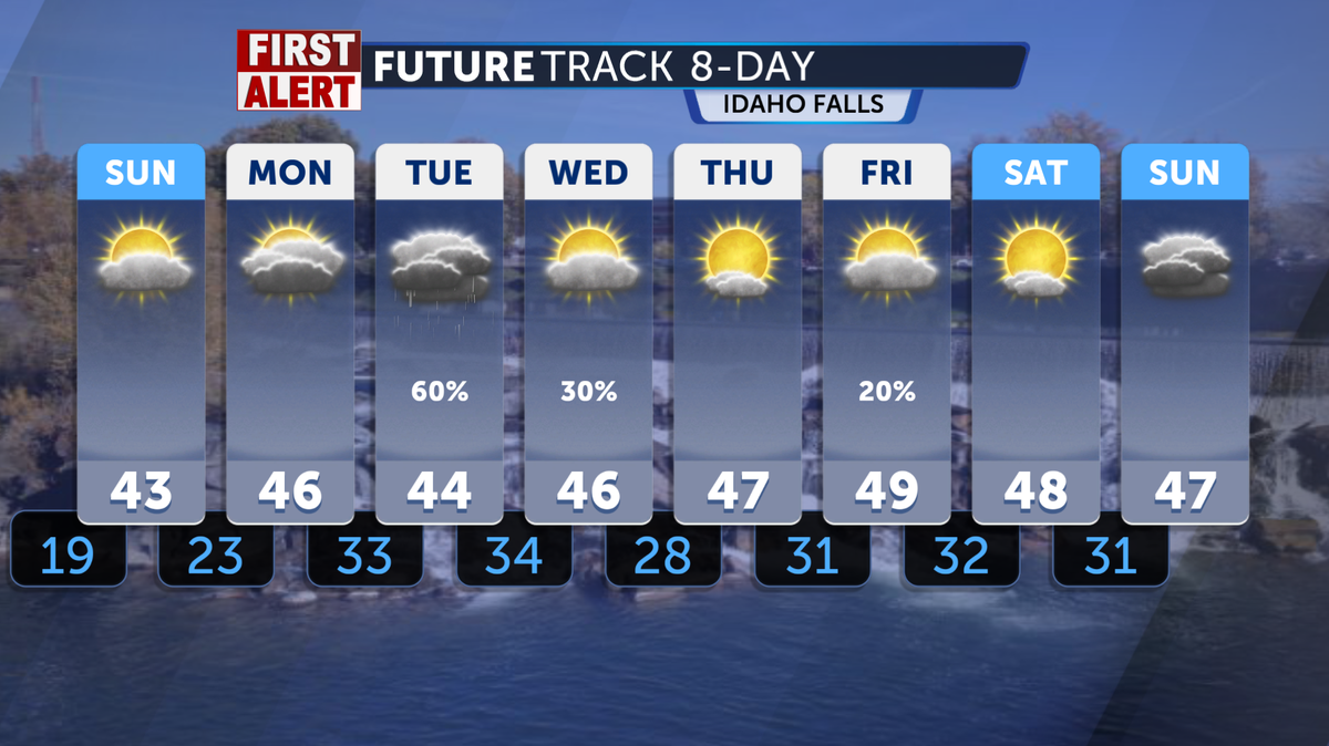
A beautiful wrap-up to the weekend will bring warmer temperatures and sunny skies as we jump into the final week of February. We’re tracking mostly sunny skies for the remainder of Sunday afternoon, with high temperatures in the mid- to upper 40s and light winds around 5 mph. Overnight, lows will drop to around 19° as partly cloudy skies set in for the Snake River Plain.
We will continue to see drier, warmer weather through the start of Monday morning and into the afternoon. The forecast will begin to change, however, on Monday night, when a fresh winter system arrives in the region, bringing a greater chance of rain and snow in the mountainous areas. This system is expected to remain in place until Wednesday.
Highs across this region this Sunday are above average, generally expected to be in the 40s, and with small precipitation chances of less than 10%. Wind gusts could reach the teens this Sunday afternoon, but nothing above the 20s is expected.
Some moisture will start to work into portions of areas above 6000 ft by Monday afternoon, after 3 pm. This increases the region’s chance of snowy conditions in the first half of next week, with dry conditions returning on Thursday and continuing through the remainder of the weekend.
We will begin this Monday with dry conditions and warmer temperatures that carry over from the weekend. The radar will be clear in the morning and early afternoon. However, a new winter weather system is expected to arrive later in the evening. Mountainous areas should anticipate snowfall by Monday night and in the following days. The system is expected to remain in place until Wednesday.
Highs across this region this Monday morning are above average, generally in the mid to upper 40s, with a low chance of precipitation. Wind gusts could reach the upper teens this Monday afternoon, but nothing above the 20 mph range is expected.
Some Pacific moisture will start to work into portions of areas above 6000 ft by Monday afternoon, after 3 pm. Low-pressure riding in from the west coast will bring a wave of fresh rain and snow towards the Idaho and Wyoming area. This increases the region’s chance of snowy conditions in the first half of next week, with dry conditions returning on Thursday and continuing through the remainder of the weekend. A weak cold front will also push through, with stronger winds by the end of this week.
Local troop 1023 took over the studio to talk all things Girl Scout cookies.
Troop 1023, one of Idaho Falls’ newest Girl Scout Troops visited the studio live this morning. This troop includes mostly has Daisy’s (the youngest) in their ranks, but they are still working hard on their goals.
The top three earners, Presley, Ellie and Caroline were here to talk about what they like about selling, what their favorite cookies, what new flavors there are, are and where you can donate.
They let us know that if you’re not into cookies, you can still donate and a box of cookies will be given to a veteran instead.
Their cute faces and fun answers–including their favorite part is “friends”–made for a warm morning here at Local News 8.
If you’d like to purchase a box, you can go to this link.